The Island they called Useless
Aruba
Aruba: from Isla Inútil to one of the worlds best beaches - the story of an island that got lucky more than once In 1499, Spanish conquistadors landed on a small island just twenty-seven kilometers off the coast of Venezuela. The islands Indigenous inhabitants - the Caquetío people, a branch of the Arawak nation - immediately stood out to the Europeans. They were tall, physically strong, and strikingly self-assured. The Spaniards called the island Isla de los Gigantes - Island of Giants. Then they searched for gold. They found none. And they renamed the island Isla Inútil - Useless Island.
It may have been one of the most inaccurate names in Caribbean history.
In the twentieth century, massive oil reserves were discovered nearby along the Venezuelan coast. Aruba became home to one of the largest oil refineries in the world. During World War II, the German navy launched a special operation to destroy the island - and failed because of a single mistake made by a gunner.
Today, Aruba is home to Eagle Beach, repeatedly ranked among the best beaches on Earth by TripAdvisor and major international travel awards.
This is the story of an island that got extraordinarily lucky several times in a row - always at exactly the right moment.
Gold, a Governor, and the Birth of Oranjestad
After Spanish colonization, most of the Caquetío population was forcibly taken to Hispaniola to work in mines, while the island itself remained sparsely populated for decades.
In 1636, the Dutch West India Company seized Aruba from Spain and incorporated it into the Dutch colonial system.
For nearly two centuries, the island remained a quiet outpost of empire.
Everything changed in 1824, when gold was discovered near Bushiribana in Aruba’s northeastern hills.
According to historical accounts, Dutch Governor Coenraad Everhardus Cantz’laar raised a toast and declared: “Long live Oranjestad! May it grow and prosper!” - honoring the Dutch House of Orange-Nassau.
That is how the small settlement of Playa became Oranjestad - “Orange Town.” Today it is a colorful capital filled with colonial architecture, waterfront promenades, marinas, cafés, boutiques, and restaurants blending Dutch, Caribbean, and South American influences.
The ruins of the Bushiribana gold smelter remain one of the island’s most photographed landmarks. Aruba’s gold rush lasted only a few decades, but it permanently reshaped the island’s future.
The Night the Island Almost Disappeared
On February 16, 1942, the German submarine U-156 surfaced near San Nicolas on Aruba’s southern coast.
By then, Aruba had become strategically vital to the Allied war effort. The Lago Oil and Transport Company refinery processed Venezuelan crude oil and produced aviation fuel for British and American forces. At the time, it was one of the largest refineries in the world.
Operation Neuland - Germany’s coordinated assault on Caribbean oil infrastructure - began here.
Torpedoes struck several tankers anchored in the harbor, killing dozens of sailors.
The submarine then surfaced to destroy the refinery itself using its deck gun.
And that is when something extraordinary happened.
The gunner forgot to remove the protective muzzle cap from the submarine’s 105-millimeter cannon.
The first shot exploded inside the barrel. One sailor was killed, another severely injured, and the submarine’s main artillery weapon was destroyed instantly.
Smaller guns caused only limited damage ashore, while the refinery survived largely intact.
There is another detail locals still remember today.
Nearby sat a ship carrying thousands of tons of explosives. Had the refinery ignited, the chain reaction could have devastated much of the island.
The gun muzzle cap survived.
So did Aruba.
After the war, the Lago refinery transformed the island’s economy. At one point, it employed more than ten thousand workers - more than Aruba’s total population had once been. Laborers arrived from across the Caribbean and Europe, helping shape the multicultural island Aruba is today.
An Island Outside the Hurricane Belt
This is not a marketing slogan. It is geography.
Aruba lies far south of the main Atlantic hurricane routes. Most tropical cyclones pass well north of the island.
That makes Aruba one of the Caribbean’s most consistently reliable destinations year-round.
For travelers from Toronto, Montreal, or New York, it means something important: even in September and October - peak hurricane season across much of the Caribbean - Aruba is usually sunny, warm, and remarkably stable.
And the key reason is wind.
The Trade Winds That Shape the Island
Northeastern trade winds blow across Aruba almost constantly. They define not only the climate, but the entire rhythm of life.
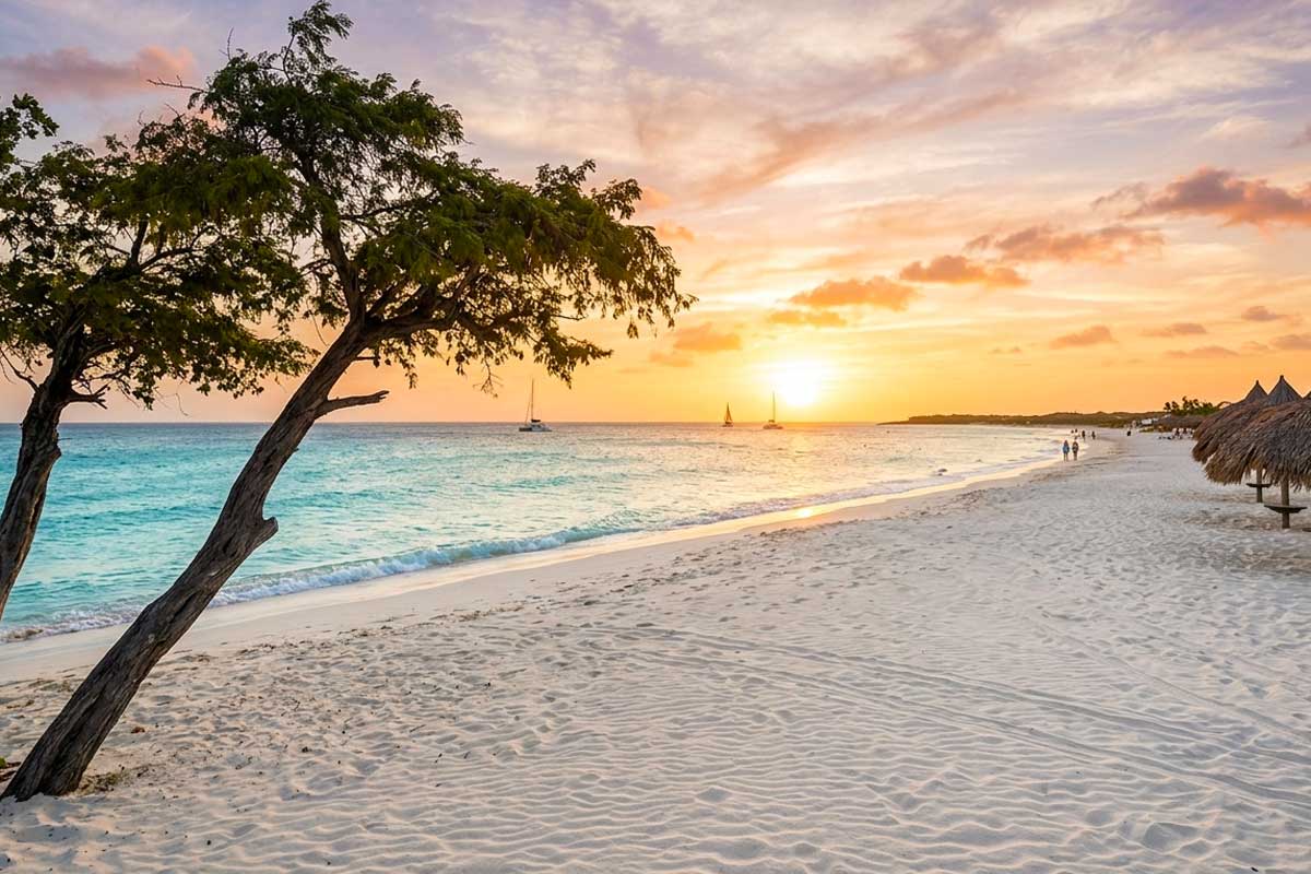
The island’s famous divi-divi trees bend permanently toward the southwest, sculpted by years of steady wind. Their twisted silhouettes have become Aruba’s unofficial symbol.
The winds make Aruba’s tropical heat feel dramatically more comfortable than many other Caribbean destinations. Even at thirty degrees Celsius, the island rarely feels stifling because the air is always moving.
The trade winds also keep mosquitoes to a minimum - an unusual advantage for a tropical island.
And they turned Aruba into one of the world’s premier windsurfing and kitesurfing destinations. Areas near Palm Beach and Malmok Beach regularly host international competitions thanks to stable, predictable conditions prized by professionals.
A Language Nearly Five Hundred Years Old
Aruba’s official languages are Dutch, English, and Papiamento.
Most residents also speak Spanish because of the island’s close proximity to Venezuela.
But Papiamento remains the emotional language of Aruba itself.
It is a fully developed Creole language shaped by Spanish, Portuguese, Dutch, African linguistic traditions, and the Indigenous Arawak heritage of the Caquetío people.
Today, Papiamento is taught in schools, used in literature, spoken in government, and celebrated in music and daily life.
A few phrases every visitor quickly learns: “Bon bini” - welcome. “Danki” - thank you. “Aruba dushi tera” - “Aruba, sweet land.” The last phrase comes directly from Aruba’s national anthem.
Flamingos, Beaches, and the Side of Aruba Many Tourists Never See
Most visitors stay along Aruba’s western coastline - Palm Beach, Eagle Beach, the resort district, restaurants, casinos, and endless stretches of white sand.
Eagle Beach is widely considered one of the finest beaches in the world. It is known for its broad shoreline, powder-soft white sand, calm turquoise water, and iconic divi-divi trees that appear in countless photographs of Aruba.
Palm Beach offers a livelier atmosphere: luxury resorts, family-friendly hotels, shopping centers, water sports, snorkeling tours, catamarans, nightlife, and restaurants lining the coast.
Aruba is also one of the Caribbean’s easiest islands for family travel. The roads are modern, healthcare standards are high, the island is considered relatively safe, supermarkets are excellent, and family-oriented activities range from submarine excursions and snorkeling cruises to wildlife encounters and calm beaches perfect for children.
But the eastern side of the island feels like a completely different world.
That is where Arikok National Park begins, covering nearly twenty percent of Aruba’s territory. The landscape changes dramatically: giant cacti, volcanic rock formations, hidden caves, wild goats, and a rugged Atlantic coastline battered by surf.
Inside Fontein Cave, ancient Caquetío rock paintings still survive on limestone walls.
And hidden among volcanic rocks is Conchi - the Natural Pool - a protected basin where seawater flows through cracks in the stone while powerful waves crash just outside.
On the private Renaissance Island, visitors encounter Aruba’s famous pink flamingos. Images of these birds standing in shallow turquoise water have become one of the island’s most recognizable modern symbols. In person, the scene feels almost surreal.
San Nicolas - once Aruba’s oil capital - is now experiencing a cultural revival. Murals cover building walls, galleries are opening, and local cafés are replacing abandoned industrial spaces. It is less polished than the resort zone, but far more revealing about Aruba’s real history.
Tap Water You Can Actually Drink
For Caribbean travel, this matters more than most people realize.
Aruba’s tap water is safe, clean, and genuinely good tasting. The island operates one of the region’s most advanced seawater desalination systems, producing drinking water standards that rival - and sometimes exceed - those in parts of North America.
For travelers, that means no constant dependence on bottled water and no concern about what comes out of the faucet.
Practical Notes
Aruba’s official currency is the Aruban florin, though U.S. dollars are accepted almost everywhere.
Canadian citizens can enter visa-free with a valid passport.
The best time to visit is generally November through May. However, unlike much of the Caribbean, Aruba remains highly attractive from June through October as well: fewer tourists, lower prices, virtually no hurricane risk, and the same constant trade winds.
The “Useless Island” turned out to be one of the Caribbean’s most valuable places.
It survived colonial abandonment, gold rushes, world war, and the rise and fall of the oil industry. Today, Aruba combines some of the world’s finest beaches with strong infrastructure, remarkable climate stability, and a surprisingly layered history.
Aruba’s story is a reminder that first impressions are often wrong - especially when the people making them are searching for gold and fail to notice everything else.